Click to see more demonstrations including Digital Twins, GIS, VR, BIM, etc.
An Integrated Command and Control Centre (ICCC), as the name suggests, works as a brain for all smart solutions implemented across a city — be it a surveillance system, smart traffic management, waste management, utility management, environmental sensors, public information system, etc.
Responsible development requires robust spatial information that is refined and constantly updated. In addition, foresight and problem-solving skills are required to put data to good use. This challenge has made Geographic Information System (GIS) invaluable to the city ecosystem to integrate every aspect of a city from conceptualization and planning to development and maintenance. Combine GIS with Cloud Computing, Big Data, IoT, Data Visualization and other kinds of technologies, to help different stakeholders prepare for exigencies, coordinate and manage response efforts, and enhance the ongoing efficiency of city operations.
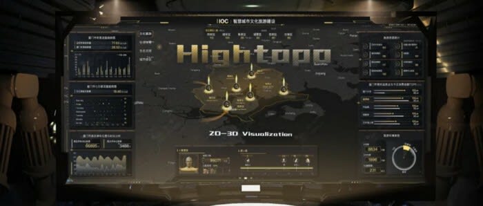
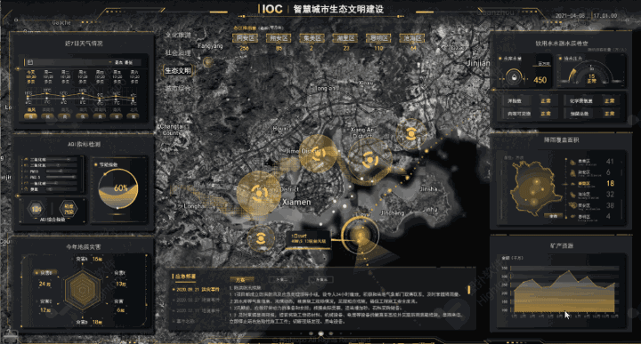
Hightopo’s "HT for Web" visualization platform integrated with GIS, supports loading geographic data from various kinds, such as 3D Tiles, Map Tiles, etc. Visualizing massive data such as POI (Point of Interest) Data, Traffic Data, Urban Infrastructure Data, etc.
The Smart City concept aims at developing a comprehensive system that uses geospatial data to enhance the understanding of complex urban systems and to improve the efficiency and security of these systems. This geospatial data concerns (i) the urban built environment such as infrastructure, buildings and public spaces, (ii) the natural environment such as biodiversity, green spaces, air quality, soil and water, and (iii) urban services such as transport, municipal waste, water, energy, health and education.
Environment
Smart city planners can model potential buildings and predict short and long-term impacts on the environment. Conservationists can choose where best to incorporate green spaces or plan conservation projects, as well as analyze air quality and spot its causes in different areas of the city.
Governance
City agencies often use location technology to share data across silos and operate more efficiently. Smart city operation platform centralizes the city’s open data and communicates with citizens about smart city initiatives.
Human Capital
Strategists and business leaders can analyze the demographics of a city’s population and use that insight to plan improvements that attract specific talent.
Mobility and Transportation
GIS empowers the assets management and long-term plans improvements of the country’s traffic. Meanwhile, IoT-based applications can be used to optimize the flow of traffic in the city.
Combined GIS with building information modelling (BIM) technology, underground infrastructures can be undertaken by knowing the precise locations of them and, to safely weave new tunnels through the built environment.
Urban Planning
City leaders, businesses, and architecture, engineering, and construction (AEC) firms can see how a structure will look before they decide to build it, measuring views from a virtual apartment window or the shadow of a skyscraper on a local park. And Digital Twin and location data is come to help. Utilizing 3D models of their physical infrastructure and location data as a connective thread to experiment with virtual plans.

Click to see the video on YouTube:
Intelligent Operations Centre for Smart City
The Business Value of Smart Cities
The "HT for Web" GIS is intended to helping users integrated location information (GIS related) into their own projects, and reduce users’ learning and investment costs for GIS. Combined with the powerful visualization engine, enable superimposed display of different map tile data, oblique photography, 3D model, POI and other data; Combined with "HT for Web" BIM, enable the combination of BIM model and GIS Visual display; Combined with "HT for Web" 3D video fusion, to achieve real-time video fusion display in GIS scenes. The "HT for Web" GIS makes the visual display of GIS data richer, clearer and more intuitive, empowers users with data-driven insight.
Conclusion
Hightopo "HT for Web" GIS provides local government with tools to develop smarter cities and deliver better services to the community. As a collaborative platform, it enables government agencies to share spatial data to break through traditional data silos and build a more transparent organization. Furthermore, the platform can be scaled to provide the tools for enterprise-wide data-driven decision making that improves management efficiency. Its mobility capabilities allow staff to access data any time, on any device, from anywhere to ensure enterprise data is always accurate and up to date.


Top comments (0)