Baremaps is aimed at being the most productive toolkit for creating custom vector tiles from OpenStreetMap data.
In this tutorial, we'll learn how to use Baremaps to import OpenStreetMap data in a Postgis database and how to create vector tiles from this data. Notice that the following steps assume that Baremaps and Postgis are installed. In addition, the tutorial requires the config.yaml and liechtenstein-latest.osm.pbf files located in the following GitHub directory. Finally, if you are in a hurry, consider skipping the "Under the Hood" sections.
Dataset
OpenStreetMap (OSM) is a free and editable map of the world. Similarly to Wikipedia, it is maintained by a community of passionate volunteers. Every week, OpenStreetMap publishes a full dump of its data in two flavours: a large XML file (about 90GB) and a more compact binary file (about 50GB) in the Protocol Buffer Format (PBF). As processing such large files can take several hours, Geofabrik regularly publishes smaller extracts of OSM for specific regions. The GitHub repository contains a tiny extract of OSM for Liechtenstein, which is suitable for experiments.
Importing OpenStreetMap Data
To begin with the tutorial, make sure you have the source files of the tutorial in your current working directory. To import the sample OSM data (liechtenstein-latest.osm.pbf) in Postgis with Baremaps, execute the following command in a terminal.
baremaps import \
  --input 'liechtenstein-latest.osm.pbf' \
  --database 'jdbc:postgresql://localhost:5432/baremaps?allowMultiQueries=true&user=baremaps&password=baremaps'
Depending on the size of the PBF file, the execution of this command may take some time. Eventually, the output produced by the command should look as follows.
[INFO ] 2020-05-14 21:01:13.958 [main] Import - 8 processors available.
[INFO ] 2020-05-14 21:01:13.972 [main] Import - Dropping tables.
[INFO ] 2020-05-14 21:01:14.170 [main] Import - Creating tables.
[INFO ] 2020-05-14 21:01:14.197 [main] Import - Creating primary keys.
[INFO ] 2020-05-14 21:01:14.443 [main] Import - Fetching input.
[INFO ] 2020-05-14 21:01:14.444 [main] Import - Populating cache.
[INFO ] 2020-05-14 21:01:15.731 [main] Import - Populating database.
[INFO ] 2020-05-14 21:01:17.400 [main] Import - Indexing geometries.
[INFO ] 2020-05-14 21:01:22.293 [main] Import - Indexing attributes.
Under the Hood (Optional)
What can we learn from this output? First, we notice that Baremaps identifies the number of processors available to parallelize the import procedure. Then it creates the database tables, the primary keys and fetches the input file. In our case, the input is a local file, however it could also be an HTTP or an S3 url.
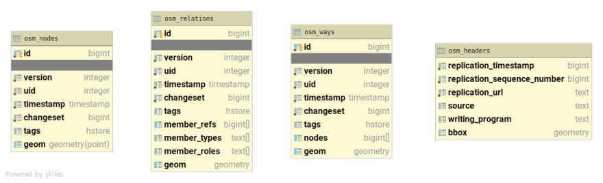
OSM's conceptual model builds upon the notions of nodes, ways and relations. In this normalized data model, a line (or way) is formed by a sequence of points (nodes) referenced by their id. In order to save denormalized geometries in Postgis (e.g. linestring, polygon, multi-polygon, etc.), Baremaps creates a cache for nodes, ways and relations. LMDB is used under the hood to achieve great performance.
After the creation of the cache, Baremaps can populate the database with geometries. The geometries are stored in three tables named after the OSM conceptual model: osm_nodes, osm_ways, and osm_relations. In order to improve performance at query time, Baremaps also creates indexes for the tags and the geometries. The following Figure displays the schema of the Postgis database created by Baremaps.
Publishing Vector Tiles
In order to create vector tiles, Baremaps uses a YAML configuration file.
This file defines general properties, a list of layers containing SQL queries to be executed against Postgis, and, optionally, styling rules. The repository contains a sample configuration file (config.yaml) which you can download to your current working directory.
Let's preview the data with the sample configuration file (config.yaml) by executing the following command in a terminal.
baremaps serve \
  --database 'jdbc:postgresql://localhost:5432/baremaps?allowMultiQueries=true&user=baremaps&password=baremaps' \
  --config 'config.yaml' \
  --watch-changes
Well done, a local tile server should have started and you can open a map of Liechtenstein in your browser (http://localhost:9000/)!
Baremaps dynamically generates a blueprint Mapbox Style from the YAML configuration file. It is aimed at quickly previsualizing the data and provides a foundation for creating more complex styles. Here, notice the flag --watch-changes, it enables the browser to reload automatically whenever the configuration file changes, which greatly accelerates the process of composing vector tiles.

Under the Hood (Optional)
Baremaps extensively rely on the fantastic ST_AsMVT functions released by the Postgis team to produce Mapbox Vector Tiles. However, in the following excerpt of the YAML configuration file, none of these concepts appear in the SQL queries.
id: 'openstreetmap'
...
layers:
  - id: 'aeroway'
    type: 'geometry'
    minZoom: 12
    maxZoom: 20
    queries:
      - SELECT id, tags, geom FROM osm_nodes WHERE tags ? 'aeroway'
      - SELECT id, tags, geom FROM osm_ways WHERE tags ? 'aeroway'
      - SELECT id, tags, geom FROM osm_relations WHERE tags ? 'aeroway' AND tags -> 'type' = 'multipolygon'
...
Why don't we see these function calls in the configuration? Baremaps wants you to focus on the content of the tiles, and relieves you from the burden of writing complex SQL queries. In fact, at runtime, Baremaps merges all the queries of the configuration file into a single optimized query that produces vector tiles.
In production, vector tiles are rarely served dynamically. Why is that so? First, a large blob store is much cheaper than a relational database to operate. Second, content delivery networks (CDNs) greatly improve web performance by caching static content close to the end user. Baremaps has been conceived with these lasting trends in mind. The following command produces a local directory containing precomputed static tiles. These tiles can be served with Apache, Nginx, or Caddy, but also copied in a blob store behind a content delivery network, such as Cloudflare, Stackpath, or Fastly.
baremaps export \
  --database 'jdbc:postgresql://localhost:5432/baremaps?allowMultiQueries=true&user=baremaps&password=baremaps' \
  --config 'config.yaml' \
  --repository 'tiles/'
Notice that Baremaps has the ability to publish tiles directly on AWS.
To do so, install the AWS Command Line Interface on your computer and run the aws configure command in the terminal. Then, add the --enable-aws flag to the previous command and replace the tiles/ directory with an S3 URL, Baremaps will take care of the rest.
Conclusion
In this tutorial, we learnt how to import OpenStreetMap data in Postgis and how to create vector tiles with Baremaps. Prior to the release of Baremaps, we believe that creating a pipeline for publishing vector tiles from OpenStreetMap data was a rather time consuming task.
As shown in this demonstration, Baremaps literally brings back the fun to creating a web mapping pipeline! Nuts and bolts still need to be tightened, but give it a try and share your impressions, it is open-source software.

Top comments (0)